LIVE. Severe thunderstorms: 6cm hailstones fell in the Landes region, 59 departments on orange alert...
After an initial round of thunderstorms in Nouvelle-Aquitaine overnight, a widespread, locally violent storm began to develop this Wednesday afternoon. It originated in the Pyrenees and will extend to the northern regions. 59 departments are on orange alert.

Huge hailstones fell on the Landes region on Wednesday, June 25, 2025.
This Wednesday, after a heatwave in many regions, where highs exceeded 35°C, even reaching 40°C in some places, a violent storm will develop this afternoon. These storms will produce severe hail, intense rain, and wind gusts sometimes exceeding 120 km/h.
• 9:59 AM
Hello everyone
Welcome to this live broadcast providing an update on the heatwave and thunderstorms expected today.
• 10:07 AM
Roads closed, trains disrupted, strong winds... The first thunderstorms have already swept through the Gironde region overnight.
Localized but strong thunderstorms hit western Gironde overnight. The Arcachon Bay and the Médoc region were the most affected areas. Strong wind gusts were recorded there: gusts of up to 135 km/h in Cazaux and 114 km/h in Pauillac.
Firefighters responded 139 times in the department, and many homes were without power: 4,000 homes were still without power in the Bay and Médoc region this morning.
Train traffic is widely disrupted in the Arcachon region, and departmental roads (RD) have been closed since 1 a.m. in the Médoc region.
>>> A complete update on the damage overnight in Gironde is available here.
•10:15 AM
Two injured, roads blocked, and homes without power in the Landes region
Also in the Landes region, a first wave of thunderstorms erupted overnight, with gusts exceeding 110 km/h, torrential rain, and intense electrical activity.
170 firefighters were mobilized overnight, and two women were injured by a falling tree.
Up to 4,000 homes were without power, and that number remained at 1,000 this morning, while several roads were closed.
>>> A full update on the damage in the Landes region is available here.
•10:18 AM
Around thirty firefighters responded to the call in the Basque Country last night
Wind, lightning, but no injuries: the Basque Country also experienced thunderstorms last night, requiring around thirty firefighters to respond.
>>> Get the latest update here.
• 10:24 a.m.
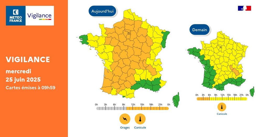
52 departments on orange alert
According to the latest map published by Météo-France at 10 a.m., 52 departments are now on orange alert for thunderstorms, including all of Nouvelle-Aquitaine, with the exception of Charente-Maritime and Deux-Sèvres.
Pour mercredi 25 juin 2025 : 🟠 52 (‼️) départements en Vigilance orange
For Wednesday, June 25, 2025: 🟠 52 (‼️) departments on Orange Alert: Pour jeudi 26 juin 2025 : 🟠 2 départements en Vigilance orange
For Thursday, June 26, 2025: 🟠 2 departments on Orange Alert Restez prudents et informés : vigilance.meteofrance.fr
• 10:30 a.m.
Pyrénées-Atlantiques, Landes, and Gironde affected from 4 p.m.
Thunderstorms are expected to begin around 4 p.m., according to Météo-France. The first departments to be affected will be Pyrénées-Atlantiques, Landes, and Gironde. These storms will then move north and east during the evening.
• 10:34 a.m.
Extreme heat before the storms
Before the arrival of the violent storms that will sweep across almost all of France, Wednesday began with intense heat. Minimum temperatures were already very high in the early morning in the southwest, with temperatures ranging from 19 to 23°C.
• 10:44 AM
Over 35°C this afternoon
This afternoon, maximum temperatures will exceed 35°C, sometimes significantly so, almost everywhere in France.
10:47 a.m.
Heavy rainfall, hailstones of 2 to 5 cm, or even more, and lightning are on the agenda.
According to Météo-France, the main risks associated with the violent storms awaiting us are "high rainfall (30 to 50 mm in 1 to 2 hours), hailstones of 2 to 5 cm, or even more, and gusts that could exceed 100 km/h (possibly 100/120 km/h). Electrical activity is also intense."

• 10:59 AM
Nearly 3,500 lightning strikes on the Aquitaine coastline last night
According to Keraunos, the night's thunderstorms were accompanied by very dense electrical activity. Nearly 3,500 lightning strikes were recorded along the Aquitaine coastline.

•11:03 AM
Some gust readings overnight in the region
The winds accompanying the overnight thunderstorms blew strongly. Gusts of over 90 km/h were recorded by nine stations in southwest New Aquitaine, which is one of the criteria for severe thunderstorms.

• 11:08 AM
Temperatures could reach 40°C locally in the center of the country today
Before the thunderstorms later today, temperatures could reach 40°C locally in the center of the country. According to Keraunos, monthly records could be set in Lyon, Saint-Etienne, Vichy, Avord, Nevers, etc.
Temperatures could also reach 40-42°C locally in the Pyrénées-Orientales.
• 11:15 a.m.
How should you behave in the event of a thunderstorm?
Lightning strikes, injuries from falling objects, flooded roads... Thunderstorms are dangerous phenomena. To protect yourself, it is recommended to stay away from trees and waterways and avoid moving around. It is recommended to take shelter in a solid building, stay indoors, not use your vehicle, and only use your phone in case of emergency.
• 11:17 AM
Some temperature readings from Tuesday night to Wednesday night
During the night from Tuesday to Wednesday, Météo-France recorded particularly high minimum temperatures. Here are some examples (provisional values):
25.0°C in St-Jean-de-Minervois (34);
24.9°C in Nice (06);
23.9°C in Marseille - Marignane (13);
23.0°C in Narbonne (11);
22.9°C in Arles (13), Toulon (83), and Menton (06);
22.6°C in Castelnaudary (11);
22.5°C in Toulouse (31);
21.5°C in Ajaccio (20);
19.9°C in Paris (75).
• 11:19 AM
Another tropical night in some parts tonight
Despite thunderstorms expected later in the day, it is expected to remain very hot tonight, according to Météo-France, which is forecasting another tropical night, particularly in Lyon and Grenoble.
However, during the daytime, a very significant drop in highs is expected, with temperatures returning to around 30°C.
• 11:25 a.m.
How can we explain this heat wave and these thunderstorms?
A heat bubble developed between Tuesday and Wednesday, particularly over the Rhône Valley, Nouvelle-Aquitaine, and Île-de-France, with temperatures reaching 38–40°C locally.
A cold drop is arriving at higher altitudes in opposition to this warm bubble, which will generate a considerable thermal contrast and trigger the extensive stormy development expected later in the day.
• 11:34 a.m.
Hailstones of 5 cm or more in the Southwest and Normandy this evening
According to La Chaîne Météo, the largest hailstones are expected to fall in the Southwest and Normandy during today's violent storms. They could be up to 5 cm in diameter, or even more.
• 11:42 AM
Risk of tornadoes, lightning, and hail: what to expect in each region?
Here are the details of the risks of dangerous phenomena during the violent thunderstorm that will begin at 4:00 PM.
Electrical activity and lightning:

Probabilité de tornade :

• 11:58 AM
Temperatures expected to drop on Thursday, before another heatwave this weekend?
After Wednesday's stormy weather, maximum temperatures will drop significantly on Thursday. But this breathable air could be short-lived. A new heatwave seems to be looming this weekend.
According to Serge Zaka, head of AgroClimat2050, "a heat dome should set in as early as Saturday, suggesting a long-lasting and widespread heatwave across the country."
"The most likely scenarios confirm the persistence of a heatwave risk at least until mid-July, due to the presence of extremely hot air further south in Europe."
Here is a projection map for Sunday, June 29 at 4:00 PM:

• 12:31 PM
Gironde affected by thunderstorms between 4 PM and 8 PM
According to an alert issued by the Gironde prefecture, thunderstorms will affect Gironde, and more broadly Nouvelle-Aquitaine, between 4 PM and 8 PM.
They are likely to generate in our region:
- Wind gusts reaching 80 to 100 km/h, with possible peaks of 110-120 km/h
- Significant electrical activity
- Medium to large hail
- Heavy rainfall totals, with intensities of 30 to 50 mm/h, and frequently 50 to 60 mm/h.
These 135 km/h at Cazaux constitute a new monthly record for the month of June and rank in the Top 6 for the most violent wind measured since the anemometer existed at the station (1950). After the 140 km/h measured during the storms of 1999. 115 km/h at Biarritz ;114 km/h at Pauillac.
• 12:37 PM
Record gust in Cazaux tonight
During the first thunderstorms that swept through the Gironde region last night, a gust of 135 km/h was measured in Cazaux. This is the monthly record for the month of June at the station, according to Meteociel.
This gust also ranks among the top 6 recorded since records began in Cazaux in 1950.
• 12:56 PM
Where are the thunderstorms at 12:55 PM?
To follow the storms' progress in real time, click here:

• 2:05 PM
Royan: Swimming banned on beaches, basement of the central market flooded
Following overnight storms, swimming is banned on Royan's beaches, as rainwater runoff could degrade the sanitary quality of bathing water. Furthermore, the interior of the central market, which was flooded, is temporarily closed.
>>> Update on the situation in Royan here. (In French)
• 2:09 PM
+5°C in one hour in Paris
With the sudden arrival of Saharan air, the temperature rose suddenly in several regions of France. For example, in Paris, the mercury rose 5°C in one hour, as Guillaume Séchet of Météovilles points out.
In Paris, the temperature jumped 5°C in 1 hour! (sudden arrival of Saharan air). The 34°C forecast around 5 p.m. is confirmed. Yesterday, a plateau around 30°C was observed from 5 p.m. to 9 p.m. (very hot air invaded the northern half at the end of the day). live > https://meteo-paris.com/station-meteo
• 2:15 p.m.
TER service interrupted from 4 p.m. in Auvergne-Rhône-Alpes
Due to thunderstorms, TER service in Auvergne-Rhône-Alpes will be interrupted from 4 p.m. this afternoon, SNCF announced.
#WeatherAlert Wednesday, June 25, thunderstorms and strong winds are expected in the #AURA region late this afternoon. Auvergne: From 4 p.m., rail traffic will be interrupted on several routes. (Timetables to come this evening) More information: here ,in French.
• 2:21 p.m.
TER Nouvelle-Aquitaine traffic disruptions late in the day
Due to thunderstorms expected starting this afternoon, TER Nouvelle-Aquitaine traffic disruptions are expected:
- Complete interruption of services between Brive-Ussel, Limoges-Ussel, and St. Sulpice-Laurière-Montluçon-Felletin starting at 7 p.m.
- Train speed restrictions starting at 7 p.m.
- Train traffic is disrupted on the Limoges-Périgueux line, with significant delays.
• 2:27 p.m.
Already significant accumulations during overnight storms in Nouvelle-Aquitaine
According to Info Climat, accumulations were significant overnight along the coastline: 56 mm in Biscarosse, 40 mm in Lège-Cap Ferret, 32 mm in Gujan, Lacanau, and Cazaux.
• 2:50 p.m.
Temperatures approaching 40°C in the center and east.
What a heatwave!!! This early afternoon, temperatures have already reached 36°C in Lyon, 37°C in Albi, and 38.6°C in Tiranges in Haute-Loire, even though it's located at an altitude of 600m!
VERY HIGH HEAT This Thursday at 2 p.m.
39.7°C > CÉRET, Pyrénées-Orientales
38.6°C > TIRANGES Haute-Loire
37.0°C > ALBI -Tarn
36.2°C > LYON - TÊTE D'OR - Rhône
• 3:03 PM
"It wasn't a flurry of wind, it was a cyclone," says Gironde coastline hit hard
The storm that hit Gironde during the night of Tuesday, June 24th to Wednesday, June 25th, was particularly violent in the Arcachon Bay and the Médoc region. By early morning, the damage was impressive.
• 3:17 p.m.
In Périgueux, parks and gardens will close from 5:30 p.m.
The parks and gardens of Périgueux will close from 5:30 p.m. until the end of the weather event, the town hall announced.
• 3:23 PM
In Léon, in the Landes region, the storm woke residents... by setting off the church bells.
In Léon, in the Landes region, the nighttime storm triggered an unexpected disturbance. Suddenly, around midnight, the church bells began ringing continuously until 1:00 AM. The storm was to blame, and it simply disrupted the bells' electronic system.
• 3:42 PM
"A derecho episode is not out of the question," according to Keraunos. What is it?
According to Keraunos, "a derecho episode is not out of the question." What is it?
The term means "straight ahead" in Spanish. It is used in contrast to tornadoes and refers to straight-line winds caused by organized and widespread thunderstorms, as opposed to the rotating winds generated by tornadoes.
In concrete terms, a derecho is a straight-line storm system that extends over 100 kilometers and travels distances of more than 400 kilometers. Well documented in the United States, these phenomena are currently rare in France.
But as a study published in 2024 showed, they could intensify with an increase in the amount of humid heat.
• 3:51 PM
First thunderstorms in the Massif Central, in stifling heat
In the Massif Central, where temperatures are 36 to 38°C, the first thunderstorms are beginning to develop.
• 3:53 PM
Storms arrive in southern Nouvelle-Aquitaine
A storm system has begun to approach southern Nouvelle-Aquitaine. According to Keraunos, its "hail potential is very high."

• 3:57 PM
Heavy rain between Bidart and Ustarritz, in the Basque Country
Currently, the first storms moving up from Spain and breaking out over the Basque Country, heading towards Bayonne, are producing heavy rain between Bidart and Ustaritz but are not causing strong winds.
The first strong #storms are breaking out in the #BasqueCountry, with locally intense rain accompanied by #hail. Images from the @Viewsurf webcam in #Bayonne. Click here.
•
•
•

No comments:
Post a Comment